Kongens Mose
Theme: Climate archives Locality: Kongens Mose
Description of a supplementary Danish GeoSite

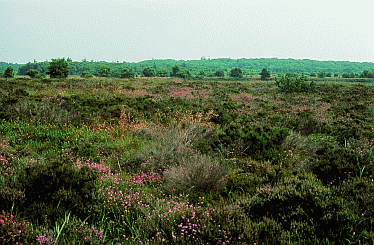
Photo: The Kongens Mose raised bog, by P. Friis Moeller.
Primary identification
1. GeoSite no.:
GS – 10-4.
2. National locality no.:
NGI - 108.
3. GeoSite name:
Kongens mose.
4. Location:
Denmark; Southern Jutland.
5. Co-ordinates UTM:
System ED50, Zone 32, x=497647, y=6096411.
6. Type of locality:
Preserved natural resort.
Primary geological features
7. Main topic:
Geological climatic archive.
8. Geo(morpho)logy:
Raised bog. The locality (the bog ~ Kongens mose) exhibits the development of vegetation from late Weichselian glacial time (~12.000 y bc) till present, relatively undisturbed by human activity. The site is located at an outer edge of a relic of Saale till, where it meets Weichselian melt-water deposits. The subsurface in the area is covered beneath ~0,5 m of discontinuous aeolian sand, which forms low dunes. It is on and over this small scale topographically and lithologically variable surface that the raised bog has developed.
This pattern of variable soils with undrained depressions fosters a variable assemblage of tree species.
The raised bog holds a lacustrine record of vegetational and historic development since the Weichselian glaciation. 7 out of the original 500 ha are still undisturbed.
9. Frame / context:
Stratigraphy, Climatology.
10. Chronostratigraphy:
Holocene (Quaternary).
11. Primary value:
Raised bog holding a lacustrine record of vegetational and historic development since the Weichselian glaciation.
12. Comparative evaluation:
Kongens mose is unique in the preserved association in between vegetation and soil profile, and in the long record of monitoring. Most other raised bogs have been more intensively affected by drainage, agriculture, cutting of peat and production of granulate sphagnum.
13. Comparable GeoSites:
In Denmark: Out of the numerous raised bogs that have existed in Denmark none are so well preserved in their almost natural conditions as Kongens mose. An analogue may be found in Lille Vildmose, GS 10-3.
Supplementary data in support of the locality
14. Delineation on a map:
15. Higth of the GeoSite:
Topography from 13 to 23 m (above sea level).
16. Area of the GeoSite:
Raised bog ~500 ha (7 ha protected).
17. Subordinate geological interests:
Archive of airborne pollution.
18. "Non"-geo interests:
Raw material. Agriculture. Leasure. Bothanics. Zoology.
19. References:
Iversen, J., 1969: Retrogressive development of a forest ecosystem demonstrated by pollen diagrams from fossil mor. Oikos Suppl. 12, p 35-49.
Kolstrup, E., 1982: Late-glacial pollen diagrams from Hjelm and Draved mose (Denmark) with the suggestion of the possibility of drught during the Earlier Dryas. Palaebotany and Palynology, 36, p 35-63.
M�ller, P.F., 2000: Natur og forskning i Draved Skov i fortid, nutid og fremtid. S�nderjysk M�nedsskrift, 2000/4, s 81-93.
Aaaby, B., 1983: Forest development, soil genesis and human activity illustrated by pollen and hypha analysis of two neighbouring podsols in Draved Forest, Denmark. Danm. Geol. Unders., II rk., nr. 114, 114 s.
20. Data sources, collections:
Data are stored at the Geological Survey of Denmark and Greenland.
21. Illustrations:
Photo: See photo at top of this page.
22. Proposers:
Dansk Geologisk Forening & Det Kongelige Danske Geografiske Selskab/Charlie Christensen.
23. Description by:
Based on M�ller, P.F., 2002; In: Gravesen, P., Jakobsen, P.R., Binderup, M. and Rasmussen, E.S.: Geologisk set, Det sydlige Jylland, Geografforlaget, Brenderup, p 108-111.
24. Recommandation:
Kongens Mose is a GeoSite.
25. Comments:
Most of the bog area is protected as a public amenity. The neighbouring wood (Draved) is classified as untouched wood. Both bog and wood are declared Natura 2000 habitat areas (784 ha).
26. Supplementary description:

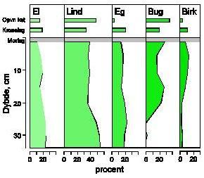
Pollen diagram from the Draved forest, next to Kongens Mose (see photo at top of this page) showing depth below the sour humus bed (indicated by a grey line and the Danish term "Morlag") versus percentage of pollen species (El=Alder, Lind=Lime, Eg=Oak, B�g=Beech, Birk=Birch). Horisontal bars at top indicate the present forestal composition in the reproduction level (Opv�kst) and level of tree crowns (Kronelaget).
|
[an error occurred while processing this directive]
List
Theme: Climate archives
 |
