L�nstrup Klint
Theme: Glacially dislocated cliffs Locality: L�nstrup Klint
Description of a Danish GeoSite

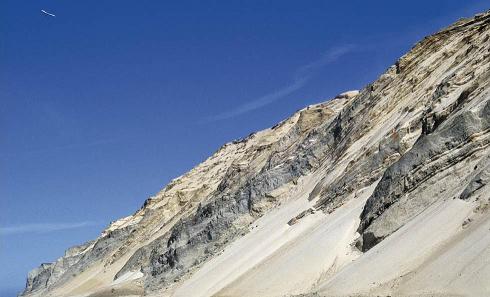
Photo: S.A. Schack Pedersen, Thrust sheets at Loenstrup klint (see interpretation under "26. Supplementary description").
Primary identification
1. GeoSite no.:
GS - 4-2.
2. National locality no.:
NGI - 10.
3. GeoSite name:
L�nstrup Klint.
4. Location:
Denmark; Western Vendsyssel.
5. Co-ordinates UTM:
System ED50, Zone 32, x=546464, y=6367470.
6. Type of locality:
Landscape and coastal cliff.
Primary geological features
7. Main topic:
a. Glacial tectonism. b. Filled in lake.
8. Geo(morpho)logy:
a. Coastal cliff exposing examples of most types of Weichselian Glacial deposits in the Kattegat-/Skagerrak area. The cliff exhibits a repeated succession of glaciotectonically imbricated flakes of meltwater clay and sand, which have been dislocated by ice-push from the north. The imbricated flakes are overlain by in situ till, marine Yoldia clay and Saxicava sand, Late Glacial lacustrine deposits from the Continental Period, Littorina beds, sea peat and aeolian sand. The location of the subsurface B�rglum fault at N�rre Lyngby is prominently expressed.
The expanses in the hindland of the cliff, Yoldia and Littorina deposits, are in visible connection to the cliff exposures. See also the interpretation of the entry photo in "26. Supplementary description".
b. The freshwater deposits include a filled in lake, which exhibits intercalated Late Glacial cultural and vertebrate remains at the N�rre Lyngby moor.
9. Frame / context:
Glaciotectonism and Stratigraphy.
10. Chronostratigraphy:
Weichsel - Holocene.
11. Primary value:
Thrusted and imbricated glacial beds.
12. Comparative evaluation:
The elements of the landscape in the hindland (the Littorina expanse in particular) are less illustrative than the area around Frederikshavn. An analogue glaciotectonic imbrication exists at Ristinge klint (GS - 24).
13. Comparable GeoSites:
In Denmark: Ristinge Klint (GS - 4-3) and the Frederikshavn area (in part the aspect "a").
Supplementary data in support of the locality
14. Delineation on a map:
15. Higth of the GeoSite:
Up to 70 m above msl.
16. Area of the GeoSite:
Ca. 15 km long and ca. 300 m east of the coast (4,5 km2).
17. Subordinate geological interests:
Endogene tectonics along the B�rglum fault.
18. "Non"-geo interests:
Archeology, Tourism.
19. References:
Bendsen, N., 1981: Rubjerg Knude Fyr fra 1899 til 1980. Vendsyssel nu og da, 1981, 5p.
Bondesen, E, og Lykke-Andersen, H., 1978: The desman, Desmana moschata (L.) - a new mammal in Denmark after the Ice Age. Natura Jutlandica, 20p.
Jessen, A., 1931: L�nstrup Klint. Danm. geol. Unders., II. rk., 49p.
Krogh, H., 1978: The Late Weichselian freshwater beds at N�rre Lyngby. C-14 dates and pollen diagram. Danm. geol. Unders. �rbog 1976.
Lykke-Andersen, A.-L., 1987: A Late Saalian , Eemian and Weichselian marine sequence at N�rre Lyngby, Vendsyssel, Denmark, Boreas, 16p. Pedersen, S.A.S., 1986: Rubjerg Knude. Varv, 3p.
Pedersen, S.A.S., 2005: Structural analysis of the Rubjerg Knude glaciotectonic complex, Vendsyssel, northern Denmark. Geol. Surv. Denmark and Greenland Bull. no. 8, 192 pp.
Weitze, H.J., 1981: Rubjerg Knude - en levende klint. Vendsyssel nu og da, 5p.
20. Data sources, collections:
...
21. Illustrations:

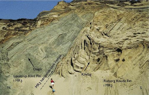
Photo: Two formations with detailed structures in ("i") the thrustsheets MR2 and MR3. "Haengende-blok rampe" means "ramp of hanging block". "Kilelag" means "Vedge shaped bed". Photo S.A. Schack Pedersen.
22. Proposers:
Dansk Geologisk Forening & Det Kongelige Danske Geografiske Selskab.
23. Description by:
Based on Sj�rring, S., 1997, in: Andersen, S. & Sj�rring, S., Geologisk Set, Det Nordlige Jylland. Skov- og Naturstyrelsen and Geografforlaget, 208 pp.
24. Recommandation:
The cliff is a GeoSite.
25. Comments:
The extend of hindland inclusion must be considered.
26. Supplementary description:
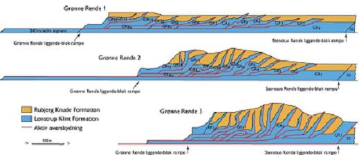
The thrusting of the lower Glacial succession, which is most prominent at Rubjerg Knude, is possibly boosted by gravity sliding on the South dipping Prequaternary Chalk surface. In the coastal profile the section with thrust faulting is flanked by undisturbed onlapping Late Glacial marine beds, exemplified at N�rre Lyngby. The marine beds are the Saxicava Sand and Yoldia Clay, which were deposited during a marine transgressive event.
In the late Glacial period the sea regressed due to the isostatic rise of the land following the deloading from the melted ice sheet, initiating the Continental Period. More lakes are known from this period, the best known of which is the one at N�rre Lyngby. This lake depression is considered to be probably developed along a subsurface fault, the B�rglum Fault, related to the Fennoscandian Border Zone.
The lake depression is filled in by a succession of fresh water sand and clay, occassional peat and fresh water sand (Elder Dryas, Aller�d and Younger Dryas periods). The cessation of the development of the lake depression in Aller�d time is interpreted from the observation that minor consolidation faults in the lower lake succesion tail out within the Aller�d beds.
The Late Glacial lacustrine beds contain remains of a.o. susliks, bevers, moles, snowhares, reindeers, and ptarmigans. Also a tanged arrowhead in flint, one of the oldest in the nordic countries and giving name to the Lyngby Cuture, has been found in the lake deposits.
During the Littorina transgression sand and mud has been deposited up to 10 metres abowe present sea level. The transgression event is datet 8.000 years b.p. based on dendrochronological evidence from tree trunks in the transgressed substrate.
The up to 25 metres high aeolian dunes covering the whole area are under continuous accretion.

Structural interpretation by S.A. Schack Pedersen of the photo at top of this page.
|
[an error occurred while processing this directive]
List
Theme: Glacially dislocated coastal cliffs
 |
